Cities are driven by a myriad of different interests, opinions, and desires. While urban areas are home to the majority of people in the world today, they are also ecologically important. Cities simultaneously shape and are largely affected by the changes in climate and biodiversity, the two key components of Earth system. Although cities cover just 3% of the Earth’s surface, they account for 75% of all carbon emissions. How we plan cities is crucial for the future of humanity and our planet. To build cities that are sustainable and can adapt to sudden changes we need collaboration across and beyond professional borders. But this is more easily said than done.
Planning urban environments is a long-term process. The future does not yet exist, only visualisations and simulations of an envisioned future. They are not often legible for those of us who are not urban planners by trade. As we extend the scope of participation to include a more diverse group of people, we need better communication tools so that everyone involved understands the topics and proposals similarly.
Technologies broaden the perception of urban space
Immersive technologies or extended reality (XR) is an umbrella term for technologies that create, augment and merge digital elements with physical space. While it represents only a small segment of the digitalisation of the urban planning processes, what makes it special, is
- the potential connection point to us humans
- an interface to present urban data and facilitate participation.
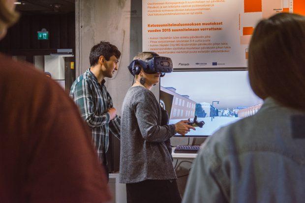
Extended reality allows us to virtually visit and experience urban spaces, be they already existing or still future visions. This opportunity can help bringing the aspects of spatial experience into consideration in different stages of the planning process e. g.
- in planning meetings
- workshops
- when collecting inputs from stakeholders via online platforms.
As compared to regular architectural visualisations, VR immerses the viewer into the planned space offering a more vivid perception of how it will look and feel when implemented.
XR also can also broaden the perception of urban space. Being able to view, for example, historical layers within a neighbourhood illustrates that the urban environment is not fixed, but ever shifting with the decisions that we make today. While augmented reality (AR) can draw attention to those aspects that are invisible or hard to notice within an existing space, virtual reality (VR) immerses the user in the perspectives presented. VR’s capacity to elicit empathy is a growing research field. With VR, we can essentially step into the shoes of someone else. This can be as simple as viewing the city from a different height and getting a feel of the elements in the urban space from that perspective. Or listening to other people’s experiences of the space as you stand immersed in it.
Human-centred approach to data-driven decision-making
Extended reality is essentially an experience and as such, can be powerful. Compared to reading through scientific materials, seeing urban areas and their changes in VR or AR are deep and rich experiences. That power comes with great responsibility. We need carefully think, how to
- select the data sources
- visually represent the data
- be transparent about those decisions.
This also requires a lot of balancing on how to translate complex science into audio-visual experience that speaks to the viewer.
The opportunities that come with extended realities knit tightly into the broader spectrum of the digitalising urban planning processes. Many cities are now producing digital twins, virtual copies of the urban environment and system. By including huge amounts of information, these aim at building a better understanding of the cities:
- their past events
- their current state
- what actions should be taken for the future.
The question is, how do we use such models and their rich data to strengthen democratic decision-making?
XR enters the picture as one potential interface for accessing and reviewing urban data. But also, as a tool that we can use for designing urban future together, in co-creation processes based on utilising the availability of increasingly rich data. With the on-going climate and biodiversity crisis, cities are facing increasingly complex challenges that call for broad collaboration. While not a silver bullet, XR technology can offer us the means to make future scenarios more understandable for a wider group of people, and help collecting their ideas on pathways into the future.
Augmented Urbans in Helsinki -video
During the past three years, the project Augmented Urbans has explored ways for extended reality technologies to support integrated urban planning in seven cities and municipalities around the Baltic Sea. The local project activities in Finland support the strategic objective of the City of Helsinki to build a better city together—with as many diverse voices as possible. The embedded video (on Youtube) captures the different tools and methods tested to enhance public participation in the context of Teollisuuskatu area development during 2019-2020.
Author
Päivi Keränen (MA) combines an educational background in New Media Design and Creative Sustainability with practical experience of working with the cities on design-based participatory urban development supported by new technologies. Working as a Project Manager at Metropolia UAS, she currently leads the project Augmented Urbans; a joint EU-funded initiative (Central Baltic Interreg) with seven cities and municipalities and university partners to explore the nexus of sustainable urban development, participatory planning and XR technologies.
See also: Augmented Urbans website.


Ei kommentteja